Aktywne Wpisy

Co sądzicie o takiej skodzinie? Szwagier mówi, żeby wziąć jednak Karoka bo większy, ale mnie się wydaje że to starsza konstrukcja.
#motoryzacja #samochody #skoda #pokazauto
#motoryzacja #samochody #skoda #pokazauto

źródło: Screenshot from 2024-07-06 18-41-20
Pobierz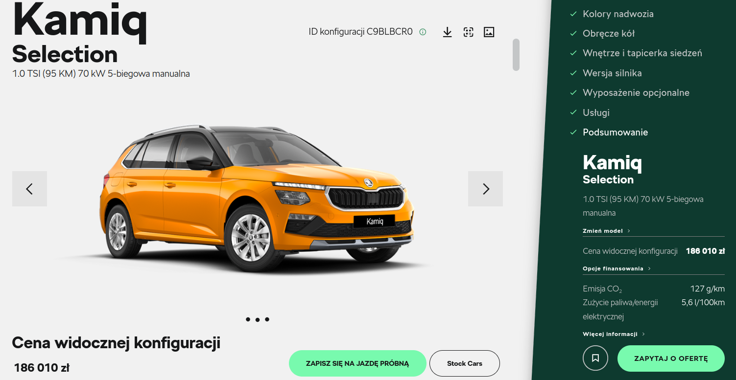

mirko_anonim +6
✨️ Obserwuj #mirkoanonim
Mirki... potrzebuje wsparcia.
Ale od początku:
Akt I
Wziąłem ślub z kobietą, którą kochałem. Dwa włoskie charaktery, częste kłótnie ale jakoś zawsze to było. Zawsze się pogodziliśmy, chociaż ona lubiła rozdrapywać rany i wyciągać brudy sprzed lat.
Mirki... potrzebuje wsparcia.
Ale od początku:
Akt I
Wziąłem ślub z kobietą, którą kochałem. Dwa włoskie charaktery, częste kłótnie ale jakoś zawsze to było. Zawsze się pogodziliśmy, chociaż ona lubiła rozdrapywać rany i wyciągać brudy sprzed lat.
Aktywne Znaleziska


#chiny
#urbanistyka
Guangzhou Urban Plan (2017-2035)
http://www.gzlpc.gov.cn/hdjl/zjyj/201802/t20180224_1543000.html
http://www.sohu.com/a/223923128_161795
City scale
2035 resident population controlled at 20 million
The draft plan proposes that the size of the population should be controlled scientifically. In 2035, the size of the permanent population should be controlled at about 20 million people. At the same time, the infrastructure public service facilities should be provided in accordance with the 25 million management service population. According to data released by the Guangzhou #!$%@? Bureau of Statistics, at the end of 2016, the resident population of Guangzhou was 14,443,500 people.
Public Transport
Up to 2000 km of urban track network by 2035
At the end of 2017, the Guangzhou Metro reported that the length of the subway line after the opening of four new lines including the southern section of the Guangzhou Metro Line 4, the first line of the 9th line, the first line of the 13th line, and the Zhicheng branch line of the 14th line Increased 81.6 kilometers to 390.6 kilometers, ranking third in the country and top ten in the world. According to the "Guangzhou Urban Rail Transit 3rd Phase Construction Plan (2017-2023)" approved by the National Development and Reform Commission in March last year, Guangzhou will build 10 new subway lines with a total length of 258.1 kilometers and a total investment of 219.6 billion yuan.By 2023, Guangzhou will form a rail transit network with 18 lines and a total length of 800 kilometers.
Urban structure
Forming a five-tier urban spatial network system
The draft plan clearly includes the area north of Guangming Expressway in Panyu District as the main urban area. The plan proposes to form an urban spatial network system of "main city district - sub-center - peripheral city - new town - village". Among them, the main city includes Liwan, Yuexiu, Tianhe and Haizhu Districts, Baiyun District, North Second Ring Expressway south of the region, Huangpu District, south of Jiulong Town and Panyu District, north of the Guangming Expressway. The main city area is the core area for undertaking scientific and technological innovation, cultural exchanges, and comprehensive service functions.
City Category:
Beautiful Livable City Vibrant Global City
Urban nature: Guangdong Province, the provincial capital, national important city, historical and cultural city, international comprehensive transportation hub, trade center, communication center, science and technology industry innovation center, and gradually build into a socialist leading global city with Chinese characteristics.
City pattern:
Constructing a hub-type network city spatial pattern
Main City: Liwan, Yuexiu, Tianhe, Haizhu four districts, south of Baiyun District North Second Ring Expressway, south of Jiulong Town, Huangpu District and north of Guangming Expressway, Panyu District.
Sub-center: Nansha District
Peripheral urban areas: Huadu City, Airport Economic Zone, Knowledge City, Southern Panyu District, Conghua City and Zengcheng City
New towns: relatively independent towns
Rural: rural residents concentrated living area
Urban ecology:
Beautiful livable flower city in harmony with human nature
Eco-network: 9 important ecological areas with concentrated distribution of ecological resources in Weiyu City; constructing a network of ecological corridors with “three vertical and five horizontal corridors”
Recreational Network: By 2035, the number of ecological parks will increase from 108 to 138, and a greenway network of 3,800 kilometers will be built, forming a 1,000-kilometer hiking trail.
Protect Rivers: By 2035, the city's surface water rate will reach 10.2%
City features:
Highlights the internationalization of Guangzhou and the charm of modern cities
General appearance:The northern part highlights the appearance of ecological forests, the central part highlights the urban features, and the southern part highlights the coastal features.
Cultural Landscape: Build three 10 km high-quality Pearl River landscape belts; protect and activate the historical city; connect a group of buildings, streets, and blocks that best reflect the historical and cultural features of Guangzhou and show the most traditional features of Guangzhou.
źródło: comment_qxfzgONygnjs3d97aHcy756LoN0WpNpg.jpg
Pobierzhttp://www.skyscrapercity.com/showthread.php?t=374269&page=42
źródło: comment_NXXrUyV9vxzZ9NiTz52f9MDyV8INfTRd.jpg
Pobierz